
From the “Mapping and Orienteering” Dept.
For those of you who are curious, I’ve scanned in some images of the route that me, my brother and his friends are taking.
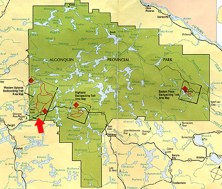
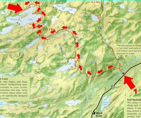
We’re leaving the house at 6:30 am, Friday. We’ll be entering Algonquin’s West-Gate (Red Arrow), just northeast of Dorset, Ontario.

Day 1: The team will hike 20 Km, traversing the Oxtongue River, which may be flooded this time of year—great, I don’t know how to swim, but I sink very well—to the northwest point of Maggie Lake. (ETA 4-5 hours). We’ll set up camp (at around 3:00 pm). Captain Win, my brother, will work on getting a fire started using the classic “bow and stick“ method. If that fails, all of us are equipped with windless lighters. Since, this is his first time trying to do such a thing, I figure that it will take him the better part of the day. I will try to fish-out some protein from the lake for the night’s meal.
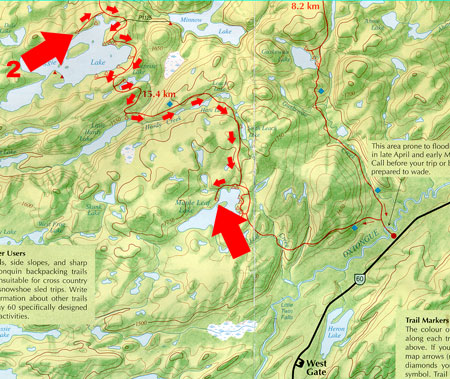
Day 2: The team will pack up camp and proceed back where we came. The hike will take us Southeast to Maple Leaf Lake (I have no idea why it’s called that—it doesn’t look remotely like a maple leaf). (ETA 3 1/2 hours) The team sets camp again, marvelling at the wonders of Mother Nature.
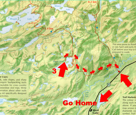
Day 3: The team does the short 5 km hike back to the car portage, where we pack up and go.
From the “Yum, Yum , Dim-Sum” Dept.
Just want to make a quick note about what I’m bringing to eat. So far, I’m bringing 4.2 lbs of food. More than enough to keep me going.
Here’s my list:
- 3 Cliff Bars (lunch for each day)
- 4 Chewy Granola bars (breakfast pick-me-ups)
- 4 packs of Lipton Cup-a-soup (chicken noodle)
- 4 packs of President’s Choice Apple Cider
- 1 bag of Mini-Oreo Cookies (snack)
- 1 bag of instant mash potatoes (filler)
- 2 bags of Lipton Sidekicks (Pesto + Bacon Carbonara)
- 1 bag of Hamburger helper Beef Stroganoff
- 1 bag of home-made, unseasoned, dehydrated ground beef
- 1 ZipLock Bag of Gorp
- Kool-aid Cherry Flavour (to flavour the water)
- Gatorade (for that deep-down body thirst)
- 1 bag of Maynard’s Winegums (sweet tooth pickings)
I also intend to catch fish, although I’m doubtful because of the relatively cold water.
All this will go into our “bear bag” (a 30L seal-line sack) and hung onto a tree like this:
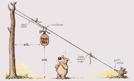
Actually, we’re too lazy for this set up, so we’re just going to hang it across a branch.
Tomorrow, I’ll put up a team profile. Hmm…we need a team name….
Cheers,
Tai